Won't you consider registering with our site? You can unlock more features of the site, leave comments and even elect to receive our "Weekly Shoveling" - a summary of all the coolest stories added each week!
It's totally free and takes a few seconds. We don't give out your e-mail or personal information to anybody! Try it!
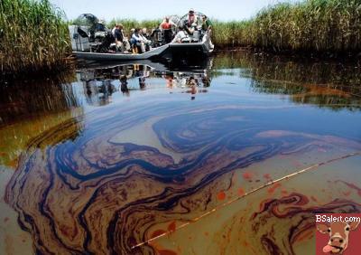
Plaquemines parish president, Billy Nungesser makes a plea to the government to take over the project and stop British Petroleum's control over the Deepwater Horizon oil spill as he watches the coastal marshes become irrevocably destroyed by the oil slick...
District 1 Council Office
Updated 7:45 pm May 19, 2010
Governor Bobby Jindal and Plaquemines Parish President Billy Nungesser took a boat trip to see the thick oil first-hand in the Pass A Loutre marsh today.
The Barrier Island Protection Plan, develop by President Nungesser, is an aggressive plan to add a new line of protection for coastal Louisiana's unique estuaries, marshes, and wetland habitats which face devastating effects as the oil reaches the marsh and continues to leak from the well site. The plan calls for the immediate utilization of the U.S. dredging fleet to begin dredge operations to build a "sand boom" along the existing barrier island chains. The sand boom would stretch along the alignment of Chandeleur, Barataria Bay, and Timbalier Bay barrier islands to provide a more reliable means of protecting against oil intrusion as compared to the current booming methods. The length of the barrier island project is approximately 80 miles.
The Louisiana Coastal Protection and Restoration Authority filed an emergency permit on Thursday, May 13, 2010 with the U.S. Army Corps of Engineers and is still awaiting the Corps to issue the permit. President Nungesser demands that the Corps issue the permit and the U.S. Coast Guard direct BP to initiate this plan.
In anticipation of receiving a permit from the Corps, the state has already begun steps to prioritize and determine the capacity of each sand borrow site needed to construct the sand boom. The state has boats out conducting surveys. Magnetometers were used to identify existing pipelines, and side-scan sonar used to develop images of the seafloor. Sampling and assessments are being performed to identify contaminated sediments and to ensure that the materials are safe and the receiving areas are clean.
OIL IMPACT
According to NOAA, the total amount of Louisiana shoreline with oil impact to date is 34.52 miles. DEQ has confirmed shoreline impacts to date on: the Chandeleur Islands, Whiskey Island, Raccoon Island, South Pass, East Fourchon/Elmers Island, Grand Isle, Trinity Island, Brush Island, and the Pass a Loutre area.
1 Article displayed.
Pursuant to Section 230 of Title 47 of the United States Code (47 USC § 230), BSAlert is a user-contributed editorial web site and does not endorse any specific content, but merely acts as a "sounding board" for the online community. Any and all quoted material is referenced pursuant to "Fair Use" (17 U.S.C. § 107). Like any information resource, use your own judgement and seek out the facts and research and make informed choices.
Powered by Percleus (c) 2005-2047 - Content Management System


 Bumper Sticker Store


 Plaquemines parish president, Billy Nungesser makes a plea to the government to take over the project and stop British Petroleum's control over the Deepwater Horizon oil spill as he watches the coastal marshes become irrevocably destroyed by the oil slick...